
Make a donation
Gear up for your next adventure:
As an Amazon Associate, this site earns from qualifying purchases at no extra cost to you.
Kandelus topographic map
Click on the map to display elevation.
Make a donation
Gear up for your next adventure:
As an Amazon Associate, this site earns from qualifying purchases at no extra cost to you.
About this map
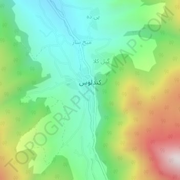
Name: Kandelus topographic map, elevation, terrain.
Location: Kandelus, بخش کجور, Nowshahr County, Mazandaran Province, Iran (36.31888 51.56574 36.32576 51.56969)
Average elevation: 1,851 m
Minimum elevation: 1,552 m
Maximum elevation: 2,409 m
Make a donation
Gear up for your next adventure:
As an Amazon Associate, this site earns from qualifying purchases at no extra cost to you.
Other topographic maps
Click on a map to view its topography, its elevation and its terrain.
Make a donation
Gear up for your next adventure:
As an Amazon Associate, this site earns from qualifying purchases at no extra cost to you.
Make a donation
Gear up for your next adventure:
As an Amazon Associate, this site earns from qualifying purchases at no extra cost to you.
Aliabad Asgarkhan
Iran > Mazandaran Province > Nowshahr County > دهستان بلده کجور > Aliabad Asgarkhan
Average elevation: -5 m