
Dietzenbach topographic map
Interactive map
Click on the map to display elevation.
Dietzenbach
Hexenberg, whose name is German for “Witches’ Mountain”, is a constituent community. It is named after the highest elevation in Offenbach district. The buildings are mostly relatively low one-family and multiple-family dwellings as well as a few smaller shops in the middle of the community.
About this map
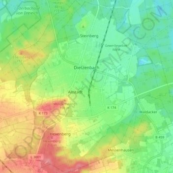
Name: Dietzenbach topographic map, elevation, terrain.
Location: Dietzenbach, Landkreis Offenbach, Hesse, 63128, Germany (49.98256 8.74756 50.03925 8.82671)
Average elevation: 155 m
Minimum elevation: 121 m
Maximum elevation: 208 m
Other topographic maps
Click on a map to view its topography, its elevation and its terrain.
Heusenstamm
Germany > Hesse > Landkreis Offenbach
Heusenstamm is one of 13 towns and communities in the Offenbach district. The town lies in the Frankfurt Rhine Main Region south of Frankfurt am Main and Offenbach am Main at an average elevation of 121 m above sea level. The town lies on the river Bieber. The lowest natural point is the Bieber's riverbed, and…
Average elevation: 129 m
Egelsbach
Germany > Hesse > Landkreis Offenbach
Egelsbach is one of 13 communities in the Offenbach district. The community lies in the Frankfurt Rhine Main Region south of the Main between Frankfurt am Main and Darmstadt at an elevation of 117 m above sea level.
Average elevation: 137 m