
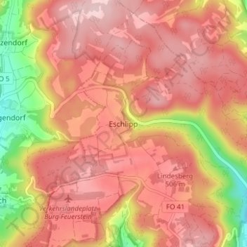
Eschlipp topographic map
Interactive map
Click on the map to display elevation.
About this map
Name: Eschlipp topographic map, elevation, terrain.
Average elevation: 464 m
Minimum elevation: 320 m
Maximum elevation: 537 m
Das im Süden der Heiligenstädter Flächenalb gelegene Dorf[2] befindet sich etwa vier Kilometer nordwestlich des Ortszentrums von Ebermannstadt auf einer Höhe von 474 m ü. NHN.[3]
Other topographic maps
Click on a map to view its topography, its elevation and its terrain.
Poxstall
Deutschland > Bayern > Landkreis Forchheim > Ebermannstadt
Poxstall, Ebermannstadt, Ebermannstadt (VGem), Landkreis Forchheim, Bayern, 91365, Deutschland
Average elevation: 417 m
Ellersberg
Deutschland > Bayern > Landkreis Forchheim > Ebermannstadt
Ellersberg, Ebermannstadt, Ebermannstadt (VGem), Landkreis Forchheim, Bayern, 91346, Deutschland
Average elevation: 470 m
Burg Feuerstein
Deutschland > Bayern > Landkreis Forchheim > Ebermannstadt > Breitenbach
Burg Feuerstein, FO 41, Breitenbach, Ebermannstadt, Ebermannstadt (VGem), Landkreis Forchheim, Bayern, 91320, Deutschland
Average elevation: 407 m
Breitenbach
Deutschland > Bayern > Landkreis Forchheim > Ebermannstadt > Breitenbach
Breitenbach, Ebermannstadt, Ebermannstadt (VGem), Landkreis Forchheim, Bayern, 91320, Deutschland
Average elevation: 368 m
Niedermirsberg
Deutschland > Bayern > Landkreis Forchheim > Ebermannstadt
Niedermirsberg, Ebermannstadt, Ebermannstadt (VGem), Landkreis Forchheim, Bayern, 91365, Deutschland
Average elevation: 434 m