
Laredo topographic map
Interactive map
Click on the map to display elevation.
About this map
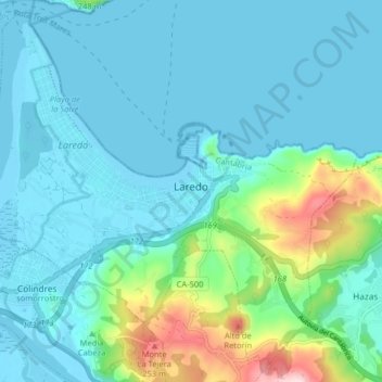
Name: Laredo topographic map, elevation, terrain.
Location: Laredo, Costa Oriental, Kantabrien, Spanien (43.38209 -3.46274 43.43777 -3.38218)
Average elevation: 53 m
Minimum elevation: -2 m
Maximum elevation: 312 m
Other topographic maps
Click on a map to view its topography, its elevation and its terrain.
Linares
Spanien > Kantabrien > Costa Oriental > Castro-Urdiales
Linares, Castro-Urdiales, Costa Oriental, Kantabrien, 39798, Spanien
Average elevation: 416 m