Geolocate

Depok topographic map

Click on the map to display elevation.

About this map

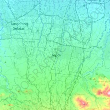
Name: Depok topographic map, elevation, terrain.

Location: Depok, West Java, 16439, Indonesia (-6.56747 106.65381 -6.24747 106.97381)

Average elevation: 101 m

Minimum elevation: 13 m

Maximum elevation: 682 m

Other topographic maps

Click on a map to view its topography, its elevation and its terrain.

Beji

Indonesia > West Java > Depok

Average elevation: 74 m

Kecamatan Tapos

Indonesia > West Java > Depok

Average elevation: 96 m

Pancoran Mas

Indonesia > West Java > Depok

Average elevation: 85 m

Gandul

Indonesia > West Java > Depok

Average elevation: 60 m

Bojongsari

Indonesia > West Java > Depok

Average elevation: 85 m

Gear up for your next adventure:

📍Handheld GPS Navigators - Reliable satellite navigation for hiking and off-road exploration
🎿Telescopic Trekking Poles - Reduces knee strain on steep topographic descents
🥾Trekking Poles - Poles to improve stability on uneven terrain
🔦Keychain LED Torches - Emergency backup light for finding gear in your pack
🧥Softshell Jackets - Breathable jackets for active outdoor use

As an Amazon Associate, this site earns from qualifying purchases at no extra cost to you.