
Badger Mountain topographic map
Interactive map
Click on the map to display elevation.
About this map
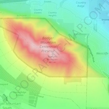
Name: Badger Mountain topographic map, elevation, terrain.
Average elevation: 294 m
Minimum elevation: 158 m
Maximum elevation: 486 m
Other topographic maps
Click on a map to view its topography, its elevation and its terrain.
Richland
United States > Washington > Benton County
Richland, Benton County, Washington, United States
Average elevation: 160 m
Hanford
United States > Washington > Benton County
Hanford, Benton County, Washington, United States
Average elevation: 123 m
Brookstone Park
United States > Washington > Benton County > Richland
Brookstone Park, Brookshire Estates, Queensgate, Richland, Benton County, Washington, United States
Average elevation: 201 m
Kennewick
United States > Washington > Benton County
Kennewick, Benton County, Washington, United States
Average elevation: 154 m