
Steinernes Haus topographic map
Interactive map
Click on the map to display elevation.
About this map
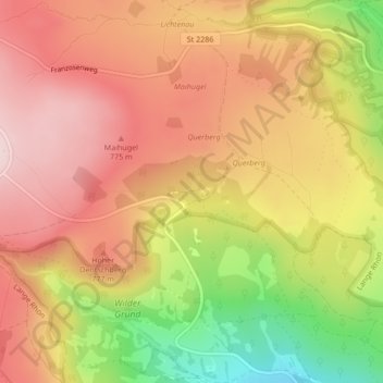
Name: Steinernes Haus topographic map, elevation, terrain.
Average elevation: 720 m
Minimum elevation: 522 m
Maximum elevation: 849 m
Other topographic maps
Click on a map to view its topography, its elevation and its terrain.
Sondernau
Deutschland > Bayern > Landkreis Rhön-Grabfeld > Oberelsbach
Sondernau, Oberelsbach, Landkreis Rhön-Grabfeld, Bayern, 97656, Deutschland
Average elevation: 435 m
Gangolfsberg
Deutschland > Bayern > Landkreis Rhön-Grabfeld > Oberelsbach
Gangolfsberg, Oberelsbach, Landkreis Rhön-Grabfeld, Bayern, 97656, Deutschland
Average elevation: 633 m