
Make a donation
Gear up for your next adventure:
As an Amazon Associate, this site earns from qualifying purchases at no extra cost to you.
Trailfingen topographic map
Click on the map to display elevation.
Make a donation
Gear up for your next adventure:
As an Amazon Associate, this site earns from qualifying purchases at no extra cost to you.
About this map
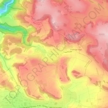
Name: Trailfingen topographic map, elevation, terrain.
Average elevation: 750 m
Minimum elevation: 588 m
Maximum elevation: 829 m
Make a donation
Gear up for your next adventure:
As an Amazon Associate, this site earns from qualifying purchases at no extra cost to you.
Other topographic maps
Click on a map to view its topography, its elevation and its terrain.
Hundersingen
Deutschland > Baden-Württemberg > Landkreis Reutlingen > Münsingen
Average elevation: 726 m
Make a donation
Gear up for your next adventure:
As an Amazon Associate, this site earns from qualifying purchases at no extra cost to you.
Gundelfingen
Deutschland > Baden-Württemberg > Landkreis Reutlingen > Münsingen
Average elevation: 715 m
Bichishausen
Deutschland > Baden-Württemberg > Landkreis Reutlingen > Münsingen
Average elevation: 709 m