
Make a donation
Gear up for your next adventure:
As an Amazon Associate, this site earns from qualifying purchases at no extra cost to you.
Samos topographic map
Click on the map to display elevation.
Make a donation
Gear up for your next adventure:
As an Amazon Associate, this site earns from qualifying purchases at no extra cost to you.
About this map
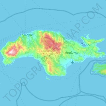
Name: Samos topographic map, elevation, terrain.
Location: Samos, Samos Regional Unit, Northern Aegean, Aegean, Greece (37.63610 26.56611 37.81311 27.06986)
Average elevation: 78 m
Minimum elevation: -1 m
Maximum elevation: 1,421 m
Make a donation
Gear up for your next adventure:
As an Amazon Associate, this site earns from qualifying purchases at no extra cost to you.
Other topographic maps
Click on a map to view its topography, its elevation and its terrain.
Balos Beach
Greece > Aegean > Samos Regional Unit > Municipal Unit of Marathokabos > Koumeika > Ormos Koumeikon
Average elevation: 66 m
Kolona
Greece > Aegean > Samos Regional Unit > Municipal Unit of Pythagoreio > Ireo
Average elevation: 30 m
Make a donation
Gear up for your next adventure:
As an Amazon Associate, this site earns from qualifying purchases at no extra cost to you.
Varella
Greece > Aegean > Samos Regional Unit > Municipal Unit of Vathy > Vathy
Average elevation: 146 m