
Make a donation
Gear up for your next adventure:
As an Amazon Associate, this site earns from qualifying purchases at no extra cost to you.
Tahat topographic map
Click on the map to display elevation.
Make a donation
Gear up for your next adventure:
As an Amazon Associate, this site earns from qualifying purchases at no extra cost to you.
Tahat
Mount Tahat (Arabic: جبل تاهات) is the highest mountain in Algeria. It sits at an elevation of 2,908 metres (9,541 ft). Other sources indicate an elevation of 3,003 metres (9,852 ft). Tahat is also the highest peak in the Hoggar Mountains. Its nearest city is Tamanrasset which is located 56 kilometres (35 mi) to the south.
Make a donation
Gear up for your next adventure:
As an Amazon Associate, this site earns from qualifying purchases at no extra cost to you.
About this map
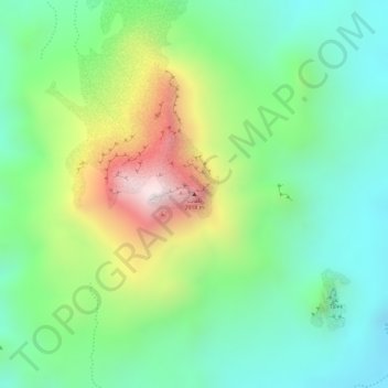
Name: Tahat topographic map, elevation, terrain.
Average elevation: 2,466 m
Minimum elevation: 2,234 m
Maximum elevation: 2,879 m
Make a donation
Gear up for your next adventure:
As an Amazon Associate, this site earns from qualifying purchases at no extra cost to you.