
Make a donation
Gear up for your next adventure:
As an Amazon Associate, this site earns from qualifying purchases at no extra cost to you.
Tsada topographic map
Click on the map to display elevation.
Make a donation
Gear up for your next adventure:
As an Amazon Associate, this site earns from qualifying purchases at no extra cost to you.
Tsada
Tsada (earlier (before 1985) written Tsadha) is a relatively big village 8 km North of Paphos city center. Although the proximity between them, the 612 m elevation difference gives to the Tsada area a totally different identity. It receives 610 millimetres (24 in) of rainfall annually. The climate is much cooler all year long (during the hot and humid summers in Paphos the temperature gap can reach 6 °C) and it also is one of the few areas in the Paphos District that snows almost every year by the end of January. Tsada was the home village of EOKA national hero Evagoras Pallikarides. Although the history of the village can be counted 500 years ago, there is no significant architectural character, and only a few residences were reconstructed in the traditional way. It can be said that the only thing that makes the village special is the astonishing view towards Paphos and its sea. Currently mass development is taking place in nearby hills, with villas being constructed over the last 5 years. The Melisovouno hill between Tsada and Koili village hosts Paphos television and radio antenna.
Make a donation
Gear up for your next adventure:
As an Amazon Associate, this site earns from qualifying purchases at no extra cost to you.
About this map
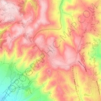
Name: Tsada topographic map, elevation, terrain.
Location: Tsada, Paphos District, Cyprus, 8540, Cyprus (34.81938 32.45524 34.85938 32.49524)
Average elevation: 526 m
Minimum elevation: 300 m
Maximum elevation: 639 m
Make a donation
Gear up for your next adventure:
As an Amazon Associate, this site earns from qualifying purchases at no extra cost to you.