
Arenzano topographic map
Interactive map
Click on the map to display elevation.
About this map
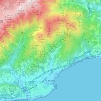
Name: Arenzano topographic map, elevation, terrain.
Location: Arenzano, Genoa, Liguria, 16011, Italy (44.39010 8.62342 44.45095 8.70853)
Average elevation: 335 m
Minimum elevation: 0 m
Maximum elevation: 1,176 m
Other topographic maps
Click on a map to view its topography, its elevation and its terrain.
Santo Stefano d'Aveto
Santo Stefano d'Aveto, Genoa, Liguria, Italy
Average elevation: 1,166 m
Villetta Di Negro
Italy > Liguria > Genoa > Genoa
Villetta Di Negro, Genoa, Liguria, 16122, Italy
Average elevation: 53 m
Sestri Levante
Sestri Levante, Genoa, Liguria, 16039, Italy
Average elevation: 114 m