
Thank you for supporting this site ❤️
Make a donation
Make a donation
Gear up for your next adventure:
As an Amazon Associate, this site earns from qualifying purchases at no extra cost to you.
Constantí topographic map
Click on the map to display elevation.
Thank you for supporting this site ❤️
Make a donation
Make a donation
Gear up for your next adventure:
As an Amazon Associate, this site earns from qualifying purchases at no extra cost to you.
About this map
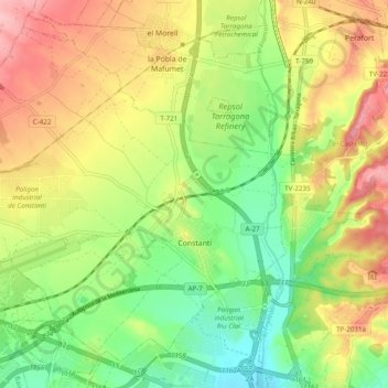
Name: Constantí topographic map, elevation, terrain.
Location: Constantí, Tarragonés, Tarragona, Cataluña, 43120, España (41.13038 1.14385 41.19350 1.23805)
Average elevation: 75 m
Minimum elevation: 9 m
Maximum elevation: 153 m
Thank you for supporting this site ❤️
Make a donation
Make a donation
Gear up for your next adventure:
As an Amazon Associate, this site earns from qualifying purchases at no extra cost to you.
Other topographic maps
Click on a map to view its topography, its elevation and its terrain.
la Nou de Gaià
España > Cataluña > Tarragonés > la Nou de Gaià > la Nou de Gaià
Average elevation: 87 m