
Make a donation
Gear up for your next adventure:
As an Amazon Associate, this site earns from qualifying purchases at no extra cost to you.
Ellison Bay topographic map
Click on the map to display elevation.
Make a donation
Gear up for your next adventure:
As an Amazon Associate, this site earns from qualifying purchases at no extra cost to you.
About this map
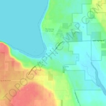
Name: Ellison Bay topographic map, elevation, terrain.
Average elevation: 194 m
Minimum elevation: 172 m
Maximum elevation: 238 m
Make a donation
Gear up for your next adventure:
As an Amazon Associate, this site earns from qualifying purchases at no extra cost to you.
Other topographic maps
Click on a map to view its topography, its elevation and its terrain.
Sturgeon Bay
United States > Wisconsin > Door County
Stevens Hill is a populated place within the city of Sturgeon Bay, just to the northeast of the downtown. The top of the hill has the highest elevation in the city. It is within Big Hill Park, which is 13.2 acres in area and is used for mountain biking, picnicking, and sledding.
Average elevation: 199 m
Washington Island
United States > Wisconsin > Door County > Town of Washington
Average elevation: 184 m
Make a donation
Gear up for your next adventure:
As an Amazon Associate, this site earns from qualifying purchases at no extra cost to you.
Sturgeon Bay
United States > Wisconsin > Door County
Stevens Hill is a populated place within the city of Sturgeon Bay, just to the northeast of the downtown. The top of the hill has the highest elevation in the city. It is within Big Hill Park, which is 13.2 acres in area and is used for mountain biking, picnicking, and sledding.
Average elevation: 199 m
Make a donation
Gear up for your next adventure:
As an Amazon Associate, this site earns from qualifying purchases at no extra cost to you.