
Sobha topographic map
Interactive map
Click on the map to display elevation.
About this map
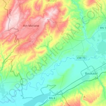
Name: Sobha topographic map, elevation, terrain.
Location: Sobha, Boukadir District, Chlef, Algeria (36.03130 0.90527 36.18154 1.17236)
Average elevation: 194 m
Minimum elevation: 55 m
Maximum elevation: 633 m
Other topographic maps
Click on a map to view its topography, its elevation and its terrain.
Boukadir
Algeria > Chlef > Boukadir District
Boukadir, Boukadir District, Chlef, Algeria
Average elevation: 263 m
Oued Sly
Algeria > Chlef > Boukadir District > Oued Sly
Oued Sly, Boukadir District, Chlef, 02011, Algeria
Average elevation: 163 m