
Make a donation
Gear up for your next adventure:
As an Amazon Associate, this site earns from qualifying purchases at no extra cost to you.
Porto Santo topographic map
Click on the map to display elevation.
Make a donation
Gear up for your next adventure:
As an Amazon Associate, this site earns from qualifying purchases at no extra cost to you.
Porto Santo
The southwest part of the island, although relatively flat, includes a series of elevations 100 meters in height or greater, such as Pico Ana Fereira (283 meters), Pico do Espigão (270 meters) and the Cabeço do Zimbralinho (183 meters). The slope of the western part of the island slopes from 150 meters to the south coast reaching the sandy beaches of Porto Santo. A third system, in the west-northwest, that includes Cabeço da Bárbara Gomes (227 meters) and Cabeço das Canelinhas (176 meters) is distinct from the areas identified. The island is encircled by an oceanic platform between 20 and 37 km2, with a minimum depth of 8 meters (Baixa do Noroeste), and limited by the flanks of a large submarine volcano.
Make a donation
Gear up for your next adventure:
As an Amazon Associate, this site earns from qualifying purchases at no extra cost to you.
About this map
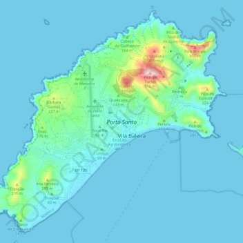
Name: Porto Santo topographic map, elevation, terrain.
Location: Porto Santo, Madeira, Portugal (33.02412 -16.39789 33.10745 -16.28928)
Average elevation: 45 m
Minimum elevation: -1 m
Maximum elevation: 489 m
Make a donation
Gear up for your next adventure:
As an Amazon Associate, this site earns from qualifying purchases at no extra cost to you.