
Make a donation
Gear up for your next adventure:
As an Amazon Associate, this site earns from qualifying purchases at no extra cost to you.
Hochgrat topographic map
Click on the map to display elevation.
Make a donation
Gear up for your next adventure:
As an Amazon Associate, this site earns from qualifying purchases at no extra cost to you.
Hochgrat
Für eine üppige und artenreiche Gebirgsflora bietet der Hochgrat günstige Voraussetzungen: Sein kalkreiches Nagelfluhgestein ist mit Sandstein- und Mergelschichten durchsetzt, so dass den Pflanzen ein breites Spektrum an Mineralien und Substratstrukturen zur Verfügung steht. Die klimatische Ausgesetztheit der Nagelfluhkette sorgt für häufige Niederschläge und für viel Wind. Mit seiner Höhe erreicht der Hochgrat die Waldgrenze (etwa 1.800 m), was einige mit Bäumen konkurrierende Gebirgsblumen begünstigt.
Make a donation
Gear up for your next adventure:
As an Amazon Associate, this site earns from qualifying purchases at no extra cost to you.
About this map
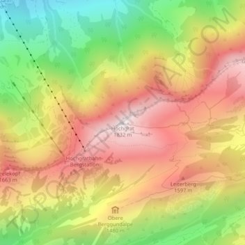
Name: Hochgrat topographic map, elevation, terrain.
Average elevation: 1,389 m
Minimum elevation: 896 m
Maximum elevation: 1,818 m
Make a donation
Gear up for your next adventure:
As an Amazon Associate, this site earns from qualifying purchases at no extra cost to you.
Other topographic maps
Click on a map to view its topography, its elevation and its terrain.
Bad Hindelang
Deutschland > Bayern > Landkreis Oberallgäu
Das Gemeindegebiet erstreckt sich in einer Höhenlage von 780 m (Ostrachbrücke bei Reckenberg) bis auf 2592 m (Hochvogel).
Average elevation: 1,274 m
Weißach
Deutschland > Bayern > Landkreis Oberallgäu
Beim Weiler Krebs wird der Fluss zu einem See aufgestaut, die Druckröhre eines Wasserkraftwerks mit über 30 Meter Höhenunterschied führt das Wasser ab. Dieses und ein kleineres Kraftwerk am Eibelebach der Weißachtal-Kraft-Werke versorgen etwa 1000 Menschen mit elektrischem Strom.
Average elevation: 993 m
Altusried
Deutschland > Bayern > Landkreis Oberallgäu
Die Höhenlage der Gemeinde reicht von 622 m ü. NHN an der Iller bei Fluhmühle (zugleich niedrigster Punkt des Landkreises Oberallgäu) bis 962 m ü. NHN im Hohentanner Wald.
Average elevation: 763 m
Make a donation
Gear up for your next adventure:
As an Amazon Associate, this site earns from qualifying purchases at no extra cost to you.