
Make a donation
Gear up for your next adventure:
As an Amazon Associate, this site earns from qualifying purchases at no extra cost to you.
Mountain Iron topographic map
Click on the map to display elevation.
Make a donation
Gear up for your next adventure:
As an Amazon Associate, this site earns from qualifying purchases at no extra cost to you.
About this map
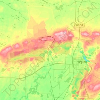
Name: Mountain Iron topographic map, elevation, terrain.
Average elevation: 462 m
Minimum elevation: 379 m
Maximum elevation: 576 m
Make a donation
Gear up for your next adventure:
As an Amazon Associate, this site earns from qualifying purchases at no extra cost to you.
Other topographic maps
Click on a map to view its topography, its elevation and its terrain.
Echo River
United States > Minnesota > Saint Louis County > Northeast St Louis
Average elevation: 393 m
Central Lakes
United States > Minnesota > Saint Louis County > Ellsburg Township
Average elevation: 408 m
Chris Lake
United States > Minnesota > Saint Louis County > Pequaywan Township
Average elevation: 494 m
Embarrass
United States > Minnesota > Saint Louis County > Embarrass Township
Average elevation: 438 m
Make a donation
Gear up for your next adventure:
As an Amazon Associate, this site earns from qualifying purchases at no extra cost to you.
Make a donation
Gear up for your next adventure:
As an Amazon Associate, this site earns from qualifying purchases at no extra cost to you.
Make a donation
Gear up for your next adventure:
As an Amazon Associate, this site earns from qualifying purchases at no extra cost to you.
Virginia
United States > Minnesota > Saint Louis County > Virginia > Virginia
Average elevation: 467 m
Make a donation
Gear up for your next adventure:
As an Amazon Associate, this site earns from qualifying purchases at no extra cost to you.
Embarrass
United States > Minnesota > Saint Louis County > Embarrass Township
Average elevation: 438 m