
Monkland topographic map
Interactive map
Click on the map to display elevation.
About this map
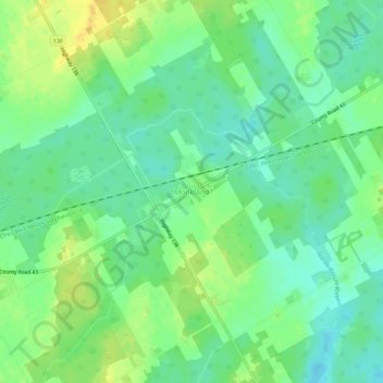
Name: Monkland topographic map, elevation, terrain.
Average elevation: 102 m
Minimum elevation: 90 m
Maximum elevation: 116 m
Other topographic maps
Click on a map to view its topography, its elevation and its terrain.
Moose Creek
Canada > Ontario > Stormont, Dundas and Glengarry Counties > North Stormont
Moose Creek, North Stormont, Stormont, Dundas and Glengarry Counties, Eastern Ontario, Ontario, K0C 1W0, Canada
Average elevation: 87 m
Finch
Canada > Ontario > Stormont, Dundas and Glengarry Counties > North Stormont
Finch, North Stormont, Stormont, Dundas and Glengarry Counties, Eastern Ontario, Ontario, Canada
Average elevation: 80 m
Finch
Canada > Ontario > Stormont, Dundas and Glengarry Counties > North Stormont
Finch, North Stormont, Stormont, Dundas and Glengarry Counties, Eastern Ontario, Ontario, K0C 1K0, Canada
Average elevation: 83 m