
Thank you for supporting this site ❤️
Make a donation
Make a donation
Gear up for your next adventure:
As an Amazon Associate, this site earns from qualifying purchases at no extra cost to you.
34639 topographic map
Click on the map to display elevation.
Thank you for supporting this site ❤️
Make a donation
Make a donation
Gear up for your next adventure:
As an Amazon Associate, this site earns from qualifying purchases at no extra cost to you.
About this map
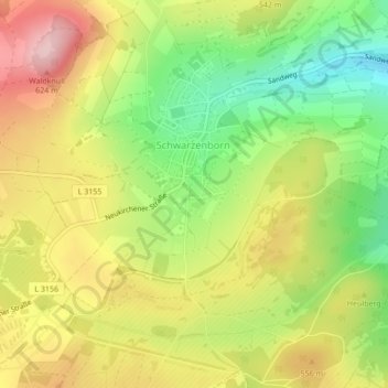
Name: 34639 topographic map, elevation, terrain.
Location: 34639, Schwarzenborn, Schwalm-Eder-Kreis, Hesse, Germany (50.87923 9.39350 50.93492 9.49466)
Average elevation: 505 m
Minimum elevation: 344 m
Maximum elevation: 628 m
Thank you for supporting this site ❤️
Make a donation
Make a donation
Gear up for your next adventure:
As an Amazon Associate, this site earns from qualifying purchases at no extra cost to you.