
Make a donation
Gear up for your next adventure:
As an Amazon Associate, this site earns from qualifying purchases at no extra cost to you.
Yew Lake topographic map
Click on the map to display elevation.
Make a donation
Gear up for your next adventure:
As an Amazon Associate, this site earns from qualifying purchases at no extra cost to you.
About this map
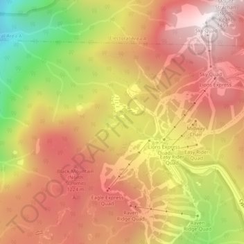
Name: Yew Lake topographic map, elevation, terrain.
Average elevation: 990 m
Minimum elevation: 336 m
Maximum elevation: 1,422 m
Make a donation
Gear up for your next adventure:
As an Amazon Associate, this site earns from qualifying purchases at no extra cost to you.
Other topographic maps
Click on a map to view its topography, its elevation and its terrain.
Lighthouse Park
Canada > British Columbia > Metro Vancouver Regional District > West Vancouver
The sword fern (Polystichum munitum), one of the most abundant ferns in North America, can be found from Alaska to California and is named for its small upward-pointing lobe that resembles a sword hilt. This fern prefers to grow in moist, coniferous low elevation environments but can survive dry periods.…
Average elevation: 22 m
Black Mountain (North Summit)
Canada > British Columbia > Metro Vancouver Regional District > West Vancouver
Average elevation: 931 m