
Make a donation
Gear up for your next adventure:
As an Amazon Associate, this site earns from qualifying purchases at no extra cost to you.
Torviscosa topographic map
Click on the map to display elevation.
Make a donation
Gear up for your next adventure:
As an Amazon Associate, this site earns from qualifying purchases at no extra cost to you.
About this map
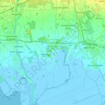
Name: Torviscosa topographic map, elevation, terrain.
Location: Torviscosa, Udine, Friuli – Venezia Giulia, 33050, Italy (45.75633 13.22568 45.87422 13.30979)
Average elevation: 3 m
Minimum elevation: -7 m
Maximum elevation: 20 m
Make a donation
Gear up for your next adventure:
As an Amazon Associate, this site earns from qualifying purchases at no extra cost to you.
Other topographic maps
Click on a map to view its topography, its elevation and its terrain.
Make a donation
Gear up for your next adventure:
As an Amazon Associate, this site earns from qualifying purchases at no extra cost to you.
Mangart Saddle
Italy > Friuli – Venezia Giulia > Udine > Tarvisio
Mangart Saddle or the Mangart Pass (Slovene: Mangartsko sedlo or Mangrtsko sedlo) is a mountain saddle in the Julian Alps in northwestern Slovenia. It has an elevation of 2,072 metres (6,798 ft). It is the most common starting point for the ascent of Mt. Mangart (2,679 m or 8,789 ft). The Mangart Road…
Average elevation: 1,780 m