
Make a donation
Gear up for your next adventure:
As an Amazon Associate, this site earns from qualifying purchases at no extra cost to you.
Lauterbourg topographic map
Click on the map to display elevation.
Make a donation
Gear up for your next adventure:
As an Amazon Associate, this site earns from qualifying purchases at no extra cost to you.
About this map
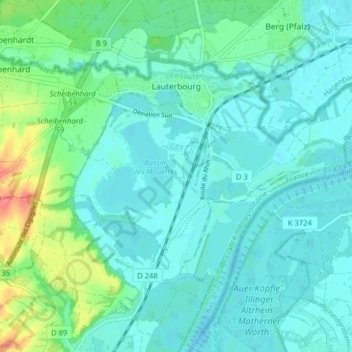
Name: Lauterbourg topographic map, elevation, terrain.
Average elevation: 118 m
Minimum elevation: 105 m
Maximum elevation: 172 m
Make a donation
Gear up for your next adventure:
As an Amazon Associate, this site earns from qualifying purchases at no extra cost to you.
Other topographic maps
Click on a map to view its topography, its elevation and its terrain.
Col du Donon
France > Grand Est > Bas-Rhin > Grandfontaine
Situé à 728 mètres d'altitude, ce col relie les villes de Schirmeck (10 km au sud-est), Raon-l'Étape (29 km au sud-ouest), Abreschviller (24 km au nord) et Sarrebourg (40 km au nord-est).
Average elevation: 694 m
Make a donation
Gear up for your next adventure:
As an Amazon Associate, this site earns from qualifying purchases at no extra cost to you.
Château de Salm
France > Grand Est > Bas-Rhin > La Broque > Salm
Construit à 809 m d’altitude sur une barre rocheuse de grès rouge d’orientation NE-SO, le château s’étend sur différents niveaux sur environ 120 m de long et sur 50 m de large. Le château primitif du XIII siècle ou Kernburg était doté au sud-ouest d’un mur bouclier faisant face à l’attaque,…
Average elevation: 652 m