
Make a donation
Gear up for your next adventure:
As an Amazon Associate, this site earns from qualifying purchases at no extra cost to you.
Skegness topographic map
Click on the map to display elevation.
Make a donation
Gear up for your next adventure:
As an Amazon Associate, this site earns from qualifying purchases at no extra cost to you.
Skegness
Skegness fronts the North Sea. It is located on a low-lying flat region called Lincoln Marsh, which runs along the coast between Skegness and the Humber and separates the coast from the upland Wolds. Much of the parish's elevation is close to sea level, although a narrow band along the seafront is 4–5 m (13–16 ft) above peaking at 6 m (20 ft) on North Parade; the A52 road is elevated at 4 m (13 ft); and there is also a short narrow bank parallel to the shoreline between the North Shore Golf Club and Seathorne which is 10 m (33 ft) above sea level.
Make a donation
Gear up for your next adventure:
As an Amazon Associate, this site earns from qualifying purchases at no extra cost to you.
About this map
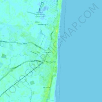
Name: Skegness topographic map, elevation, terrain.
Location: Skegness, East Lindsey, Lincolnshire, England, United Kingdom (53.12018 0.29858 53.18005 0.35683)
Average elevation: 2 m
Minimum elevation: -5 m
Maximum elevation: 12 m
Lincolnshire trails, hiking, mountain biking, running and outdoor activities
Make a donation
Gear up for your next adventure:
As an Amazon Associate, this site earns from qualifying purchases at no extra cost to you.
Other topographic maps
Click on a map to view its topography, its elevation and its terrain.
The Lymn
United Kingdom > England > Lincolnshire > East Lindsey > Thorpe St. Peter
Average elevation: 2 m
Make a donation
Gear up for your next adventure:
As an Amazon Associate, this site earns from qualifying purchases at no extra cost to you.
Make a donation
Gear up for your next adventure:
As an Amazon Associate, this site earns from qualifying purchases at no extra cost to you.
Acre Bridge
United Kingdom > England > Lincolnshire > East Lindsey > Conisholme
Average elevation: 2 m
Make a donation
Gear up for your next adventure:
As an Amazon Associate, this site earns from qualifying purchases at no extra cost to you.
Make a donation
Gear up for your next adventure:
As an Amazon Associate, this site earns from qualifying purchases at no extra cost to you.
Wainfleet Haven
United Kingdom > England > Lincolnshire > East Lindsey > Wainfleet Clough
Average elevation: 3 m
Make a donation
Gear up for your next adventure:
As an Amazon Associate, this site earns from qualifying purchases at no extra cost to you.
Halton Fenside
United Kingdom > England > Lincolnshire > East Lindsey > Little Steeping
Average elevation: 8 m
Make a donation
Gear up for your next adventure:
As an Amazon Associate, this site earns from qualifying purchases at no extra cost to you.
Make a donation
Gear up for your next adventure:
As an Amazon Associate, this site earns from qualifying purchases at no extra cost to you.
Louth Navigation
United Kingdom > England > Lincolnshire > East Lindsey > Alvingham
Average elevation: 8 m
Make a donation
Gear up for your next adventure:
As an Amazon Associate, this site earns from qualifying purchases at no extra cost to you.
Make a donation
Gear up for your next adventure:
As an Amazon Associate, this site earns from qualifying purchases at no extra cost to you.
Belleau Bridge
United Kingdom > England > Lincolnshire > East Lindsey > Aby > Belleau
Average elevation: 30 m
Make a donation
Gear up for your next adventure:
As an Amazon Associate, this site earns from qualifying purchases at no extra cost to you.
Ashby by Partney
United Kingdom > England > Lincolnshire > East Lindsey > Halton Holegate
Average elevation: 20 m
Make a donation
Gear up for your next adventure:
As an Amazon Associate, this site earns from qualifying purchases at no extra cost to you.
Fishtoft Drove
United Kingdom > England > Lincolnshire > East Lindsey > Frithville
Average elevation: 4 m
Kirkby Fenside
United Kingdom > England > Lincolnshire > East Lindsey > East Kirkby
Average elevation: 12 m
Make a donation
Gear up for your next adventure:
As an Amazon Associate, this site earns from qualifying purchases at no extra cost to you.
Make a donation
Gear up for your next adventure:
As an Amazon Associate, this site earns from qualifying purchases at no extra cost to you.
Bag Enderby
United Kingdom > England > Lincolnshire > East Lindsey > Bag Enderby
Average elevation: 56 m
Make a donation
Gear up for your next adventure:
As an Amazon Associate, this site earns from qualifying purchases at no extra cost to you.
Sutton le Marsh
United Kingdom > England > Lincolnshire > East Lindsey > Sutton-on-Sea > Sutton le Marsh
Average elevation: 1 m
Low Hameringham
United Kingdom > England > Lincolnshire > East Lindsey > Low Hameringham
Average elevation: 72 m
Poolham
United Kingdom > England > Lincolnshire > East Lindsey > Horsington > Poolham
Average elevation: 18 m
Make a donation
Gear up for your next adventure:
As an Amazon Associate, this site earns from qualifying purchases at no extra cost to you.
Boothby
United Kingdom > England > Lincolnshire > East Lindsey > Welton le Marsh
Average elevation: 12 m
Make a donation
Gear up for your next adventure:
As an Amazon Associate, this site earns from qualifying purchases at no extra cost to you.
Bowser's Corner
United Kingdom > England > Lincolnshire > East Lindsey > New Leake
Average elevation: 1 m
Make a donation
Gear up for your next adventure:
As an Amazon Associate, this site earns from qualifying purchases at no extra cost to you.