Geolocate

Dartington topographic map

Click on the map to display elevation.

About this map

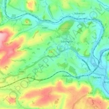
Name: Dartington topographic map, elevation, terrain.

Location: Dartington, South Hams, Devon, Devon and Torbay, England, United Kingdom (50.42521 -3.76654 50.46207 -3.68182)

Average elevation: 66 m

Minimum elevation: -1 m

Maximum elevation: 197 m

Devon trails, hiking, mountain biking, running and outdoor activities

Other topographic maps

Click on a map to view its topography, its elevation and its terrain.

Week

United Kingdom > England > Devon > South Hams > Dartington

Average elevation: 49 m

Gear up for your next adventure:

🧥Breathable Waterproof Jackets - Essential rain protection for the unpredictable British climate
🔦Keychain LED Torches - Emergency backup light for finding gear in your pack
GPS Outdoor Watches - Watches with GPS tracking for hiking and exploration
🛌Sleeping Mats - Insulated mats for comfortable outdoor sleeping
🐕Dog Hiking Gear - Equipment for hiking safely with dogs

As an Amazon Associate, this site earns from qualifying purchases at no extra cost to you.