
Huete topographic map
Interactive map
Click on the map to display elevation.
About this map
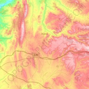
Name: Huete topographic map, elevation, terrain.
Location: Huete, Cuenca, Castile-La Mancha, 16500, Spain (39.88107 -2.76745 40.30404 -2.45927)
Average elevation: 888 m
Minimum elevation: 582 m
Maximum elevation: 1,171 m
Other topographic maps
Click on a map to view its topography, its elevation and its terrain.
Moncalvillo del Huete
Spain > Castile-La Mancha > Huete
Moncalvillo del Huete, Huete, Cuenca, Castile-La Mancha, Spain
Average elevation: 815 m