
Town of Salina topographic map
Interactive map
Click on the map to display elevation.
About this map
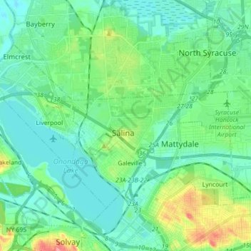
Name: Town of Salina topographic map, elevation, terrain.
Location: Town of Salina, Onondaga County, New York, United States (43.07198 -76.25443 43.13835 -76.11527)
Average elevation: 126 m
Minimum elevation: 106 m
Maximum elevation: 190 m
Other topographic maps
Click on a map to view its topography, its elevation and its terrain.
Long Branch
United States > New York > Town of Salina > Long Branch
Long Branch, Town of Salina, Onondaga County, New York, 13090, United States
Average elevation: 118 m