
Thank you for supporting this site ❤️
Make a donation
Make a donation
Gear up for your next adventure:
As an Amazon Associate, this site earns from qualifying purchases at no extra cost to you.
Grupont topographic map
Click on the map to display elevation.
Thank you for supporting this site ❤️
Make a donation
Make a donation
Gear up for your next adventure:
As an Amazon Associate, this site earns from qualifying purchases at no extra cost to you.
About this map
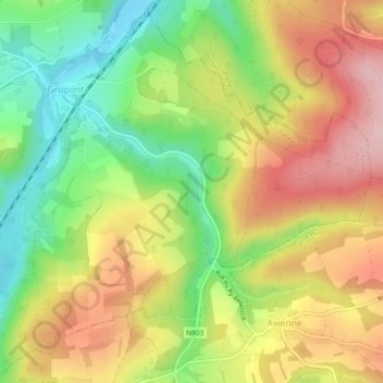
Name: Grupont topographic map, elevation, terrain.
Location: Grupont, Tellin, Neufchâteau, Luxembourg, Wallonia, Belgium (50.07029 5.27047 50.09853 5.31662)
Average elevation: 324 m
Minimum elevation: 222 m
Maximum elevation: 429 m
Thank you for supporting this site ❤️
Make a donation
Make a donation
Gear up for your next adventure:
As an Amazon Associate, this site earns from qualifying purchases at no extra cost to you.