Geolocate

Chelynch topographic map

Click on the map to display elevation.

About this map

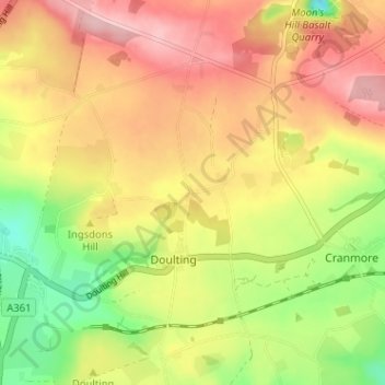
Name: Chelynch topographic map, elevation, terrain.

Location: Chelynch, Doulting, Somerset, England, BA4 4PY, United Kingdom (51.17400 -2.52295 51.21400 -2.48295)

Average elevation: 216 m

Minimum elevation: 123 m

Maximum elevation: 296 m

Somerset trails, hiking, mountain biking, running and outdoor activities

Other topographic maps

Click on a map to view its topography, its elevation and its terrain.

Doulting

United Kingdom > England > Somerset > Doulting

Average elevation: 183 m

Gear up for your next adventure:

Insulated Travel Mugs - Keep drinks hot while surveying the landscape from a summit
Camping Shelters - Emergency and lightweight shelters for outdoor use
🧥Softshell Jackets - Breathable jackets for active outdoor use
🪓Outdoor Multitools - Versatile tools for hiking and camping
🛑Emergency Bivvy Bags - Heat-reflective survival bags for unexpected nights out

As an Amazon Associate, this site earns from qualifying purchases at no extra cost to you.