Geolocate

Flowood topographic map

Click on the map to display elevation.

About this map

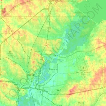
Name: Flowood topographic map, elevation, terrain.

Location: Flowood, Rankin County, Mississippi, 39232, United States (32.27837 -90.17958 32.39568 -89.96401)

Average elevation: 97 m

Minimum elevation: 70 m

Maximum elevation: 138 m

Other topographic maps

Click on a map to view its topography, its elevation and its terrain.

Lakeland

United States > Mississippi > Rankin County > Richland

Average elevation: 90 m

Johns

United States > Mississippi > Rankin County

Average elevation: 118 m

Value

United States > Mississippi > Rankin County > Brandon

Average elevation: 125 m

Cleary

United States > Mississippi > Rankin County

Average elevation: 103 m

Lakeshore

United States > Mississippi > Rankin County

Average elevation: 92 m

Plainview

United States > Mississippi > Rankin County > Richland

Average elevation: 96 m

Sinai

United States > Mississippi > Rankin County

Average elevation: 89 m

Gear up for your next adventure:

Lightweight Solo Tents - Backpacking tents designed for wild camping in the UK highlands
🪢Paracord - Multi-purpose cord for camping and survival
🎒Hiking Daypacks - Compact backpacks ideal for short hikes and excursions
🗺️Scratch-off Peak Maps - Track your progress climbing Munros or Wainwrights
🔋Lithium AA Batteries - Long-lasting power that performs well in cold mountain weather

As an Amazon Associate, this site earns from qualifying purchases at no extra cost to you.