
Make a donation
Gear up for your next adventure:
As an Amazon Associate, this site earns from qualifying purchases at no extra cost to you.
Jacksonville topographic map
Click on the map to display elevation.
Make a donation
Gear up for your next adventure:
As an Amazon Associate, this site earns from qualifying purchases at no extra cost to you.
About this map
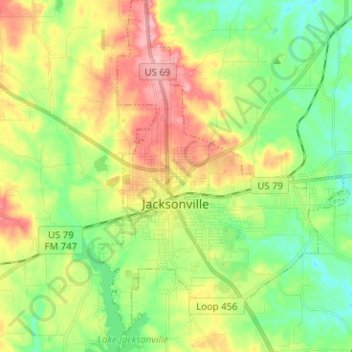
Name: Jacksonville topographic map, elevation, terrain.
Location: Jacksonville, Cherokee County, Texas, 75766, United States (31.91861 -95.29804 32.02550 -95.20822)
Average elevation: 152 m
Minimum elevation: 104 m
Maximum elevation: 222 m
Make a donation
Gear up for your next adventure:
As an Amazon Associate, this site earns from qualifying purchases at no extra cost to you.
Other topographic maps
Click on a map to view its topography, its elevation and its terrain.
Jacksonville
United States > Texas > Cherokee County > Jacksonville > Jacksonville
Average elevation: 154 m
Make a donation
Gear up for your next adventure:
As an Amazon Associate, this site earns from qualifying purchases at no extra cost to you.