
Make a donation
Gear up for your next adventure:
As an Amazon Associate, this site earns from qualifying purchases at no extra cost to you.
Albertville topographic map
Click on the map to display elevation.
Make a donation
Gear up for your next adventure:
As an Amazon Associate, this site earns from qualifying purchases at no extra cost to you.
Albertville
The city sits at an elevation of 1,060 feet (320 m) atop Sand Mountain, a plateau that in this area is about 15 miles (24 km) wide. The Tennessee Valley Divide passes through the southern part of the city. The majority of the city drains north to Short Creek, a tributary of the Tennessee River, while the southern part drains to Slab Creek, a west-flowing tributary of the Locust Fork of the Black Warrior River. The current slogan of Albertville is "The Heart of Sand Mountain", which can be seen on the welcome sign coming into the city.
Make a donation
Gear up for your next adventure:
As an Amazon Associate, this site earns from qualifying purchases at no extra cost to you.
About this map
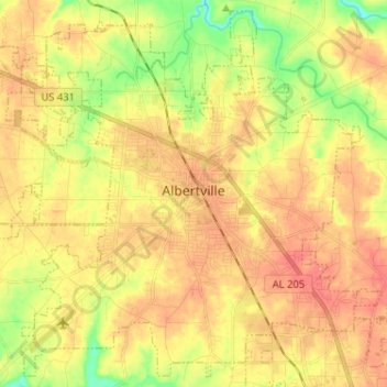
Name: Albertville topographic map, elevation, terrain.
Location: Albertville, Marshall County, Alabama, 35950, United States (34.21637 -86.27448 34.31681 -86.14596)
Average elevation: 309 m
Minimum elevation: 254 m
Maximum elevation: 356 m
Make a donation
Gear up for your next adventure:
As an Amazon Associate, this site earns from qualifying purchases at no extra cost to you.
Other topographic maps
Click on a map to view its topography, its elevation and its terrain.
Make a donation
Gear up for your next adventure:
As an Amazon Associate, this site earns from qualifying purchases at no extra cost to you.