
Guanxian County topographic map
Interactive map
Click on the map to display elevation.
About this map
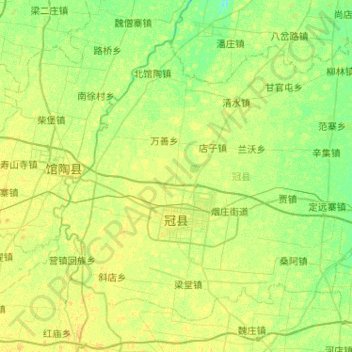
Name: Guanxian County topographic map, elevation, terrain.
Location: Guanxian County, Liaocheng, Shandong, 252500, China (36.36459 115.26564 36.70266 115.77922)
Average elevation: 41 m
Minimum elevation: 33 m
Maximum elevation: 48 m
Other topographic maps
Click on a map to view its topography, its elevation and its terrain.
Tai'an City
China > Shandong > Tai'an City
Tai'an City, Shandong, 271000, China
Average elevation: 161 m
Binzhou City
China > Shandong > Binzhou City
Binzhou City, Shandong, 256600, China
Average elevation: 15 m