Geolocate

Berthin topographic map

Click on the map to display elevation.

About this map

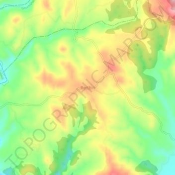
Name: Berthin topographic map, elevation, terrain.

Location: Berthin, Bilaspur, Himachal Pradesh, 174029, India (31.39793 76.61976 31.43793 76.65976)

Average elevation: 621 m

Minimum elevation: 539 m

Maximum elevation: 711 m

Other topographic maps

Click on a map to view its topography, its elevation and its terrain.

Ghumarwin

India > Himachal Pradesh > Bilaspur

Average elevation: 779 m

Gear up for your next adventure:

🎒Hiking Child Carriers - Explore the outdoors with the whole family safely
🧭Emergency Beacons - Safety beacons for remote outdoor locations
🕶️Glacier Goggles - Maximum protection for high-altitude snow topography
🕶️Polarized Sunglasses - Reduces glare from snow and water when reading terrain
🥄Titanium Camping Sporks - The ultimate lightweight utensil for trail meals

As an Amazon Associate, this site earns from qualifying purchases at no extra cost to you.