
Vosselaar topographic map
Interactive map
Click on the map to display elevation.
About this map
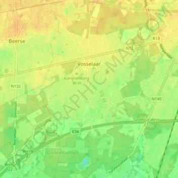
Name: Vosselaar topographic map, elevation, terrain.
Location: Vosselaar, Turnhout, Antwerp, Flanders, 2350, Belgium (51.28502 4.83715 51.32718 4.91453)
Average elevation: 23 m
Minimum elevation: 7 m
Maximum elevation: 32 m
Other topographic maps
Click on a map to view its topography, its elevation and its terrain.
Rijkevorsel
Rijkevorsel, Turnhout, Antwerp, Flanders, 2310, Belgium
Average elevation: 24 m
Meer
Belgium > Antwerp > Turnhout > Hoogstraten
Meer, Hoogstraten, Turnhout, Antwerp, Flanders, 2321, Belgium
Average elevation: 11 m
Grobbendonk
Belgium > Antwerp > Turnhout > Grobbendonk
Grobbendonk, Turnhout, Antwerp, Flanders, Belgium
Average elevation: 10 m