Geolocate

Astromeritis topographic map

Click on the map to display elevation.

About this map

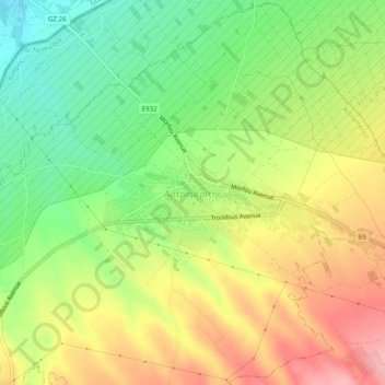
Name: Astromeritis topographic map, elevation, terrain.

Location: Astromeritis, Nicosia District, Cyprus (35.11999 33.01749 35.15999 33.05749)

Average elevation: 165 m

Minimum elevation: 100 m

Maximum elevation: 238 m

Gear up for your next adventure:

🔋Power Banks - Portable chargers for long outdoor trips
🧼Technical Clothing Wash - Special soap to clean and restore waterproof membranes
🧥Softshell Jackets - Breathable jackets for active outdoor use
GPS Outdoor Watches - Watches with GPS tracking for hiking and exploration
🧺Mesh Stuff Sacks - Breathable storage for wet gear or camp organization

As an Amazon Associate, this site earns from qualifying purchases at no extra cost to you.