
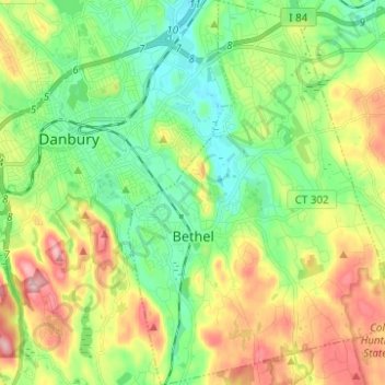
Bethel topographic map
Interactive map
Click on the map to display elevation.
About this map
Name: Bethel topographic map, elevation, terrain.
Average elevation: 157 m
Minimum elevation: 79 m
Maximum elevation: 292 m
Other topographic maps
Click on a map to view its topography, its elevation and its terrain.
King Street
United States > Connecticut > Western Connecticut Planning Region > Danbury
Average elevation: 237 m
South End
United States > Connecticut > Western Connecticut Planning Region > Stamford
Average elevation: 11 m
Long Ridge
United States > Connecticut > Western Connecticut Planning Region > Stamford
Average elevation: 126 m
Wataba Lake
United States > Connecticut > Western Connecticut Planning Region > Ridgefield
Average elevation: 205 m
Byram
United States > Connecticut > Western Connecticut Planning Region > Greenwich
Average elevation: 19 m
West Norwalk
United States > Connecticut > Western Connecticut Planning Region > Norwalk
Average elevation: 50 m
Deer Hill
United States > Connecticut > Western Connecticut Planning Region > Danbury
Average elevation: 135 m
Godfrey Corner
United States > Connecticut > Western Connecticut Planning Region > Weston
Average elevation: 110 m
Town Open Space (Ashford Lane)
United States > Connecticut > Western Connecticut Planning Region > Newtown
Average elevation: 200 m
Roxbury
United States > Connecticut > Western Connecticut Planning Region > Stamford
Average elevation: 48 m
Glenville
United States > Connecticut > Western Connecticut Planning Region > Greenwich
Average elevation: 54 m
North Stamford
United States > Connecticut > Western Connecticut Planning Region > Stamford
Average elevation: 89 m
Palmers Hill
United States > Connecticut > Western Connecticut Planning Region > Stamford
Average elevation: 31 m
Belltown
United States > Connecticut > Western Connecticut Planning Region > Stamford
Average elevation: 32 m
Mianus
United States > Connecticut > Western Connecticut Planning Region > Greenwich
Average elevation: 23 m
Taylor Corners
United States > Connecticut > Western Connecticut Planning Region > New Fairfield
Average elevation: 226 m
Contentment Island
United States > Connecticut > Western Connecticut Planning Region > Darien
Average elevation: 63 m
Beckettville
United States > Connecticut > Western Connecticut Planning Region > Danbury
Average elevation: 155 m
Candlewood Orchards
United States > Connecticut > Western Connecticut Planning Region > Brookfield
Average elevation: 141 m
Riverside
United States > Connecticut > Western Connecticut Planning Region > Greenwich
Average elevation: 13 m
Candlewood Springs
United States > Connecticut > Western Connecticut Planning Region > New Milford
Average elevation: 146 m
Byram
United States > Connecticut > Western Connecticut Planning Region > Greenwich
Average elevation: 19 m
Ponus
United States > Connecticut > Western Connecticut Planning Region > New Canaan
Average elevation: 77 m
Old Baldy
United States > Connecticut > Western Connecticut Planning Region > Norwalk
Average elevation: 59 m
Hunting Ridge
United States > Connecticut > Western Connecticut Planning Region > Stamford
Average elevation: 81 m
Riverbank
United States > Connecticut > Western Connecticut Planning Region > Stamford
Average elevation: 72 m
Honey Hill
United States > Connecticut > Western Connecticut Planning Region > Wilton
Average elevation: 126 m