
Make a donation
Gear up for your next adventure:
As an Amazon Associate, this site earns from qualifying purchases at no extra cost to you.
Jaca topographic map
Click on the map to display elevation.
Make a donation
Gear up for your next adventure:
As an Amazon Associate, this site earns from qualifying purchases at no extra cost to you.
Jaca
Jaca has a submediterranean climate (Köppen: Cfb) bordering a submediterranean climate (Köppen: Cfa) with strong continental influences caused by the city's high altitude of 820 metres (2,690 ft). Winters are cool and summers are warm, with hot daytime temperatures but relatively cool nights. There isn't any real dry season, but the rainiest seasons are autumn and spring. The average precipitation is 768 millimetres (30.2 in) per year. Frost is common and so is snowfall, snow being common from late November to early March. Heavy snowfalls are sporadic and usually occur during cold spells. Jaca's average annual temperature is 12.2 °C (54.0 °F).
Make a donation
Gear up for your next adventure:
As an Amazon Associate, this site earns from qualifying purchases at no extra cost to you.
About this map
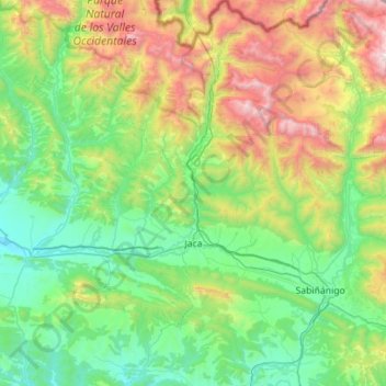
Name: Jaca topographic map, elevation, terrain.
Location: Jaca, Jacetania, Huesca, Aragon, Spain (42.41503 -0.70159 42.82795 -0.39912)
Average elevation: 1,223 m
Minimum elevation: 576 m
Maximum elevation: 2,993 m
Make a donation
Gear up for your next adventure:
As an Amazon Associate, this site earns from qualifying purchases at no extra cost to you.
Other topographic maps
Click on a map to view its topography, its elevation and its terrain.
Make a donation
Gear up for your next adventure:
As an Amazon Associate, this site earns from qualifying purchases at no extra cost to you.