
Make a donation
Gear up for your next adventure:
As an Amazon Associate, this site earns from qualifying purchases at no extra cost to you.
Council Bluffs topographic map
Click on the map to display elevation.
Make a donation
Gear up for your next adventure:
As an Amazon Associate, this site earns from qualifying purchases at no extra cost to you.
Council Bluffs
Council Bluffs covers a unique topographic region originally composed of prairie and savanna in the Loess Hills with extensive wetlands and deciduous forest along the Missouri River. Excellent vistas can be had from KOIL Point at Fairmont Park, the Lincoln Monument, Kirn Park, and the Lewis and Clark Monument. Lake Manawa State Park is located at the southern edge of the city.
Make a donation
Gear up for your next adventure:
As an Amazon Associate, this site earns from qualifying purchases at no extra cost to you.
About this map
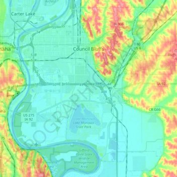
Name: Council Bluffs topographic map, elevation, terrain.
Location: Council Bluffs, Pottawattamie County, Iowa, United States (41.16725 -95.92725 41.29073 -95.75109)
Average elevation: 315 m
Minimum elevation: 291 m
Maximum elevation: 386 m
Make a donation
Gear up for your next adventure:
As an Amazon Associate, this site earns from qualifying purchases at no extra cost to you.
Other topographic maps
Click on a map to view its topography, its elevation and its terrain.