
Saint-Hilaire topographic map
Interactive map
Click on the map to display elevation.
About this map
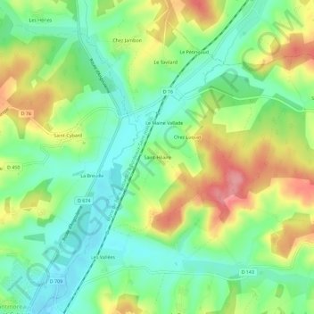
Name: Saint-Hilaire topographic map, elevation, terrain.
Average elevation: 116 m
Minimum elevation: 77 m
Maximum elevation: 175 m
Other topographic maps
Click on a map to view its topography, its elevation and its terrain.
Chez Pascaud
France > Nouvelle-Aquitaine > Charente > Montmoreau > Saint-Amant-de-Montmoreau
Chez Pascaud, Saint-Amant-de-Montmoreau, Montmoreau, Angoulême, Charente, Nouvelle-Aquitaine, France métropolitaine, 16190, France
Average elevation: 112 m