
Wind Gap topographic map
Interactive map
Click on the map to display elevation.
About this map
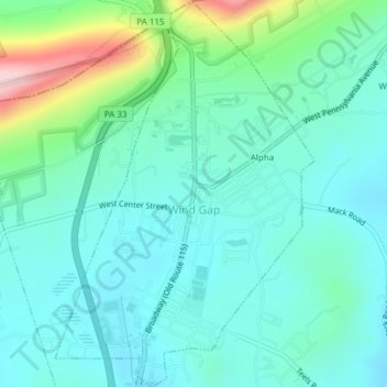
Name: Wind Gap topographic map, elevation, terrain.
Location: Wind Gap, Northampton County, Pennsylvania, United States (40.83493 -75.30521 40.86362 -75.27978)
Average elevation: 255 m
Minimum elevation: 201 m
Maximum elevation: 454 m
Wind Gap is located at 40°50′47″N 75°17′30″W / 40.84639°N 75.29167°W / 40.84639; -75.29167 (40.846429, -75.291631). According to the U.S. Census Bureau, the borough has a total area of 1.4 square miles (3.6 km2), of which 0.73% is water. Wind Gap is located 21 miles (34 km) north of Allentown in the Lehigh Valley and 50 miles (80 km) southeast of Scranton, in the Wyoming Valley, or the Scranton/Wilkes-Barre metropolitan area. Wind Gap's elevation is 755 feet (230 m) above sea level.
Other topographic maps
Click on a map to view its topography, its elevation and its terrain.
Bethlehem
United States > Pennsylvania > Northampton County
Bethlehem, Northampton County, Pennsylvania, United States
Average elevation: 120 m
Bangor
United States > Pennsylvania > Northampton County
Bangor, Northampton County, Pennsylvania, United States
Average elevation: 198 m
Allen Township
United States > Pennsylvania > Northampton County
Allen Township, Northampton County, Pennsylvania, 18067, United States
Average elevation: 139 m
Brodhead
United States > Pennsylvania > Northampton County > Bethlehem Township
Brodhead, Bethlehem Township, Northampton County, Pennsylvania, 18020, United States
Average elevation: 115 m
Williams Township
United States > Pennsylvania > Northampton County
Williams Township, Northampton County, Pennsylvania, United States
Average elevation: 131 m
Northwood Heights
United States > Pennsylvania > Northampton County > Palmer Township > Palmer Heights
Northwood Heights, Palmer Heights, Palmer Township, Northampton County, Pennsylvania, 18045, United States
Average elevation: 110 m
Mount Bethel
United States > Pennsylvania > Northampton County > Upper Mount Bethel Township
Mount Bethel, Upper Mount Bethel Township, Northampton County, Pennsylvania, 18351, United States
Average elevation: 156 m
Hellertown
United States > Pennsylvania > Northampton County
Hellertown, Northampton County, Pennsylvania, United States
Average elevation: 107 m
Bethlehem
United States > Pennsylvania > Northampton County > Bethlehem
Bethlehem, Northampton County, Pennsylvania, 18108, United States
Average elevation: 149 m
Bushkill Township
United States > Pennsylvania > Northampton County > Bushkill Township
Bushkill Township, Northampton County, Pennsylvania, 18091, United States
Average elevation: 214 m
Newport
United States > Pennsylvania > Northampton County > Newport
Newport, Northampton, Northampton County, Pennsylvania, 18037, United States
Average elevation: 113 m
Nazareth
United States > Pennsylvania > Northampton County > Nazareth
Nazareth, Northampton County, Pennsylvania, United States
Average elevation: 149 m
Easton
United States > Pennsylvania > Northampton County
Easton, Northampton County, Pennsylvania, United States
Average elevation: 109 m