
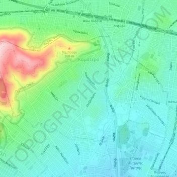
Municipal Unit of Kamatero topographic map
Interactive map
Click on the map to display elevation.
About this map
Name: Municipal Unit of Kamatero topographic map, elevation, terrain.
Average elevation: 153 m
Minimum elevation: 84 m
Maximum elevation: 365 m
Other topographic maps
Click on a map to view its topography, its elevation and its terrain.
Peristeri
Greece > Attica > Regional Unit of West Athens
Peristeri, Municipality of Peristeri, Regional Unit of West Athens, Attica, 121 34, Greece
Average elevation: 223 m
Municipality of Aigaleo
Greece > Attica > Regional Unit of West Athens
Municipality of Aigaleo, Regional Unit of West Athens, Attica, Greece
Average elevation: 46 m
Municipality of Petroupoli
Greece > Attica > Regional Unit of West Athens
Municipality of Petroupoli, Regional Unit of West Athens, Attica, 132 31, Greece
Average elevation: 222 m
Municipality of Peristeri
Greece > Attica > Regional Unit of West Athens
Municipality of Peristeri, Regional Unit of West Athens, Attica, Greece
Average elevation: 80 m