
Pöcking topographic map
Interactive map
Click on the map to display elevation.
About this map
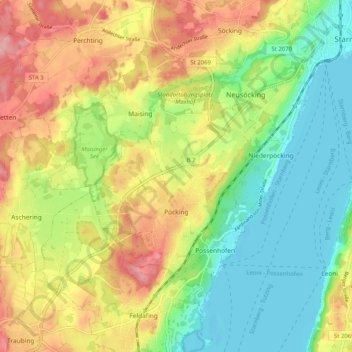
Name: Pöcking topographic map, elevation, terrain.
Location: Pöcking, Landkreis Starnberg, Bayern, 82343, Deutschland (47.94828 11.23065 47.99888 11.33215)
Average elevation: 638 m
Minimum elevation: 582 m
Maximum elevation: 711 m
Other topographic maps
Click on a map to view its topography, its elevation and its terrain.
Gauting
Deutschland > Bayern > Landkreis Starnberg
Gauting, Landkreis Starnberg, Bayern, 82131, Deutschland
Average elevation: 593 m
Söcking
Deutschland > Bayern > Landkreis Starnberg > Starnberg > Söcking
Söcking, Starnberg, Wörthsee, Landkreis Starnberg, Bayern, 82237, Deutschland
Average elevation: 651 m