
Make a donation
Gear up for your next adventure:
As an Amazon Associate, this site earns from qualifying purchases at no extra cost to you.
Donaldsonville topographic map
Click on the map to display elevation.
Make a donation
Gear up for your next adventure:
As an Amazon Associate, this site earns from qualifying purchases at no extra cost to you.
About this map
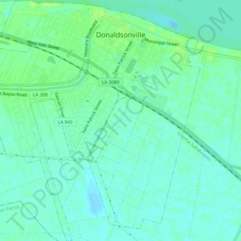
Name: Donaldsonville topographic map, elevation, terrain.
Average elevation: 6 m
Minimum elevation: 0 m
Maximum elevation: 14 m
Make a donation
Gear up for your next adventure:
As an Amazon Associate, this site earns from qualifying purchases at no extra cost to you.
Other topographic maps
Click on a map to view its topography, its elevation and its terrain.
Geismar
United States > Louisiana > Ascension Parish
Geismar is an unincorporated community in Ascension Parish, Louisiana, United States and is at the heart of Louisiana's chemical corridor. The community is part of the Baton Rouge metropolitan statistical area. Geismar is south of Prairieville and west of Gonzales. The community has Three schools, Dutchtown…
Average elevation: 7 m
Make a donation
Gear up for your next adventure:
As an Amazon Associate, this site earns from qualifying purchases at no extra cost to you.