
Make a donation
Gear up for your next adventure:
As an Amazon Associate, this site earns from qualifying purchases at no extra cost to you.
Cotobade topographic map
Click on the map to display elevation.
Make a donation
Gear up for your next adventure:
As an Amazon Associate, this site earns from qualifying purchases at no extra cost to you.
About this map
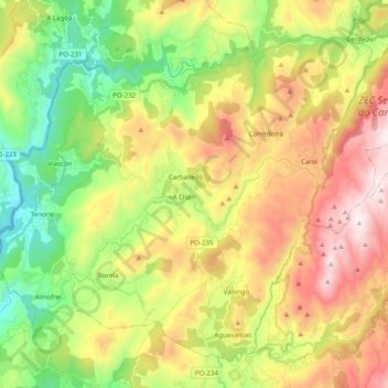
Name: Cotobade topographic map, elevation, terrain.
Average elevation: 443 m
Minimum elevation: 28 m
Maximum elevation: 990 m
Make a donation
Gear up for your next adventure:
As an Amazon Associate, this site earns from qualifying purchases at no extra cost to you.
Other topographic maps
Click on a map to view its topography, its elevation and its terrain.
Make a donation
Gear up for your next adventure:
As an Amazon Associate, this site earns from qualifying purchases at no extra cost to you.
Serra do Candán
España > Galicia > Tabeirós - Tierra de Montes
Las principales cumbres son el Alto de San Bieito -también llamado monte de San Bento- (1017 metros), El Coco (969 metros), Seixiños Blancos (905 metros), Chamor (815 metros) y Alto de San Sebastián (750 metros). La sierra del Candán está incluida en la Red Natura por la riqueza de sus ecosistemas, que…
Average elevation: 777 m
O Montillón de Arriba
España > Galicia > Tabeirós - Tierra de Montes > A Estrada
Average elevation: 508 m
Make a donation
Gear up for your next adventure:
As an Amazon Associate, this site earns from qualifying purchases at no extra cost to you.
Make a donation
Gear up for your next adventure:
As an Amazon Associate, this site earns from qualifying purchases at no extra cost to you.
Vilar Forcarei
España > Galicia > Tabeirós - Tierra de Montes > Forcarei > Vilar Forcarei
Average elevation: 594 m
Make a donation
Gear up for your next adventure:
As an Amazon Associate, this site earns from qualifying purchases at no extra cost to you.