Geolocate

Waverly topographic map

Click on the map to display elevation.

About this map

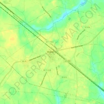
Name: Waverly topographic map, elevation, terrain.

Location: Waverly, Sussex County, Virginia, United States (37.01850 -77.12450 37.05302 -77.07273)

Average elevation: 33 m

Minimum elevation: 19 m

Maximum elevation: 40 m

Other topographic maps

Click on a map to view its topography, its elevation and its terrain.

Yale

United States > Virginia > Sussex County

Average elevation: 31 m

Homeville

United States > Virginia > Sussex County

Average elevation: 30 m

Gear up for your next adventure:

🦶Anti-Blister Balms - Protect your feet before long topographic expeditions
📸Action Camera Chest Mounts - Record your ascent following topographic paths hands-free
🔦Waterproof LED Headlamps - Hands-free lighting for evening treks and emergency navigation
🧢Thermal Beanie Hats - Prevent heat loss from the head in windy summit conditions
🥾Hiking Boot Waterproofing Wax - Maintain the lifespan of your leather trekking boots

As an Amazon Associate, this site earns from qualifying purchases at no extra cost to you.