Geolocate

Cibuntu topographic map

Click on the map to display elevation.

About this map

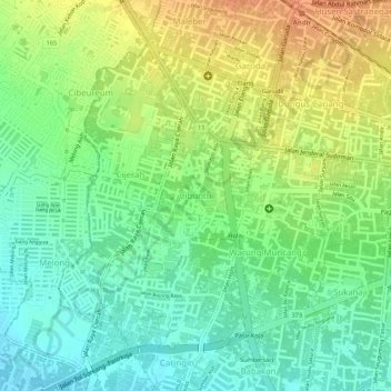
Name: Cibuntu topographic map, elevation, terrain.

Location: Cibuntu, Bandung Kulon, Bandung, West Java, Java, Indonesia (-6.92714 107.56570 -6.91464 107.57625)

Average elevation: 712 m

Minimum elevation: 691 m

Maximum elevation: 735 m

Other topographic maps

Click on a map to view its topography, its elevation and its terrain.

Sungai penuh sampah

Indonesia > West Java > Bandung > Situ Saeur

Average elevation: 688 m

Gear up for your next adventure:

🎒Hiking Backpacks - Comfortable backpacks for day hikes and multi-day treks
🩹Hiking First Aid Kits - Compact medical kits tailored for trail injuries and emergencies
🧊Insulated Flasks - Keeps drinks hot or cold during hikes
🧣Fleece Neck Warmers - Extra insulation for winter topographic surveys
🔋Solar Power Banks - Keep your GPS and phone charged during multi-day expeditions

As an Amazon Associate, this site earns from qualifying purchases at no extra cost to you.