
Make a donation
Gear up for your next adventure:
As an Amazon Associate, this site earns from qualifying purchases at no extra cost to you.
Meteora Municipality topographic map
Click on the map to display elevation.
Make a donation
Gear up for your next adventure:
As an Amazon Associate, this site earns from qualifying purchases at no extra cost to you.
About this map
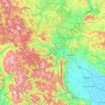
Name: Meteora Municipality topographic map, elevation, terrain.
Average elevation: 860 m
Minimum elevation: 91 m
Maximum elevation: 2,364 m
Make a donation
Gear up for your next adventure:
As an Amazon Associate, this site earns from qualifying purchases at no extra cost to you.
Other topographic maps
Click on a map to view its topography, its elevation and its terrain.
Make a donation
Gear up for your next adventure:
As an Amazon Associate, this site earns from qualifying purchases at no extra cost to you.
Pyrgos Kalabakas (Tower of Kalabaka)
Greece > Thessaly and Central Greece > Trikala Regional Unit > Kalabaka
Average elevation: 336 m
Devil's tower
Greece > Thessaly and Central Greece > Trikala Regional Unit > Καλαμπάκα
Average elevation: 414 m