
Make a donation
Gear up for your next adventure:
As an Amazon Associate, this site earns from qualifying purchases at no extra cost to you.
Pontresina topographic map
Click on the map to display elevation.
Make a donation
Gear up for your next adventure:
As an Amazon Associate, this site earns from qualifying purchases at no extra cost to you.
Pontresina
Before 2017, the municipality was located in the Oberengadin sub-district of the Maloja district, after 2017 it was part of the Maloja Region. It sits in Val Bernina, which is the highest altitude valley that branches off the Upper Engadin Valley. The municipality includes the highest mountain of the canton, Piz Bernina. Other high summits are Piz Zupò and Piz Palü. Pontresina is a noted tourist destination in its own right, but is often overshadowed by its more famous neighbor St. Moritz.
Make a donation
Gear up for your next adventure:
As an Amazon Associate, this site earns from qualifying purchases at no extra cost to you.
About this map
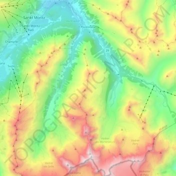
Name: Pontresina topographic map, elevation, terrain.
Location: Pontresina, Maloja, Grisons, 7504, Switzerland (46.36607 9.86964 46.51226 10.05434)
Average elevation: 2,580 m
Minimum elevation: 1,715 m
Maximum elevation: 4,010 m
Make a donation
Gear up for your next adventure:
As an Amazon Associate, this site earns from qualifying purchases at no extra cost to you.
Other topographic maps
Click on a map to view its topography, its elevation and its terrain.
Albulapass
Switzerland > Grisons > Maloja > La Punt Chamues-ch
The Albula Pass is an important axis from central Graubünden to Engadin. It is traversed by a paved road from Thusis to La Punt, via Bergün. It is also traversed by the Albula Railway, although at a lower elevation through the Albula Tunnel (1,820 m), from Thusis to Bever, also via Bergün.
Average elevation: 2,560 m
Make a donation
Gear up for your next adventure:
As an Amazon Associate, this site earns from qualifying purchases at no extra cost to you.
Berninapass
Switzerland > Grisons > Maloja > Pontresina
The building of the road began in 1842. Head of engineers was Rudolf Albertini (1821–1896) from Zuoz. The work was finished in 1865 and a hospice at an elevation of 2,307 metres (7,569 ft) was also opened. Since this time the road has been widened several times. Since 1965 it has been open all year round,…
Average elevation: 2,351 m
Make a donation
Gear up for your next adventure:
As an Amazon Associate, this site earns from qualifying purchases at no extra cost to you.
Make a donation
Gear up for your next adventure:
As an Amazon Associate, this site earns from qualifying purchases at no extra cost to you.
Lägh dal Lunghin
Switzerland > Grisons > Maloja
Lägh dal Lunghin (German: Lunghinsee) is a lake at an elevation of 2484 m, below the peak of Piz Lunghin, in the Graubünden, Switzerland. It is considered the source of the Inn River.
Average elevation: 2,456 m
Make a donation
Gear up for your next adventure:
As an Amazon Associate, this site earns from qualifying purchases at no extra cost to you.
Casaccia
Switzerland > Grisons > Maloja
Casaccia is a village located in the Val Bregaglia, in the Swiss canton of Graubünden. It lies at an altitude of 1,458 metres above sea level, at the southern foot of Piz Lunghin. The village belongs to the municipality of Bregaglia.
Average elevation: 1,929 m
Make a donation
Gear up for your next adventure:
As an Amazon Associate, this site earns from qualifying purchases at no extra cost to you.