
Make a donation
Gear up for your next adventure:
As an Amazon Associate, this site earns from qualifying purchases at no extra cost to you.
Seruyan topographic map
Click on the map to display elevation.
Make a donation
Gear up for your next adventure:
As an Amazon Associate, this site earns from qualifying purchases at no extra cost to you.
About this map
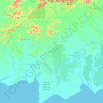
Name: Seruyan topographic map, elevation, terrain.
Location: Seruyan, Central Kalimantan, Kalimantan, Indonesia (-3.54274 111.44598 -0.69716 112.84622)
Average elevation: 82 m
Minimum elevation: -3 m
Maximum elevation: 1,537 m
Make a donation
Gear up for your next adventure:
As an Amazon Associate, this site earns from qualifying purchases at no extra cost to you.
Other topographic maps
Click on a map to view its topography, its elevation and its terrain.
Make a donation
Gear up for your next adventure:
As an Amazon Associate, this site earns from qualifying purchases at no extra cost to you.
Make a donation
Gear up for your next adventure:
As an Amazon Associate, this site earns from qualifying purchases at no extra cost to you.
Make a donation
Gear up for your next adventure:
As an Amazon Associate, this site earns from qualifying purchases at no extra cost to you.
Puruk Cahu
Indonesia > Central Kalimantan > Murung Raya
Puruk Cahu is crossed by one of the most important rivers in Borneo, Barito River. This town is situated on a hilly land at the northeastern portion of Central Kalimantan. The altitude of this town is actually varied between 70 and 300 metres above sea level. Due to its proximity to the equator, Puruk Cahu…
Average elevation: 46 m
Make a donation
Gear up for your next adventure:
As an Amazon Associate, this site earns from qualifying purchases at no extra cost to you.
Make a donation
Gear up for your next adventure:
As an Amazon Associate, this site earns from qualifying purchases at no extra cost to you.
Make a donation
Gear up for your next adventure:
As an Amazon Associate, this site earns from qualifying purchases at no extra cost to you.
Make a donation
Gear up for your next adventure:
As an Amazon Associate, this site earns from qualifying purchases at no extra cost to you.
Tanjung Puting National Park
Indonesia > Central Kalimantan > West Kotawaringin
Average elevation: 8 m
Bukit Baka Bukit Raya National Park
Indonesia > Central Kalimantan > Katingan
Average elevation: 307 m
Make a donation
Gear up for your next adventure:
As an Amazon Associate, this site earns from qualifying purchases at no extra cost to you.
Make a donation
Gear up for your next adventure:
As an Amazon Associate, this site earns from qualifying purchases at no extra cost to you.